Short answer
Harbetsuvan Tepesi is a small Early Pre-Pottery Neolithic hilltop in the Tek Tek Mountains, about 7 km from Karahan Tepe, with a rectangular building, paired T-shaped pillars and carved human imagery — the Taş Tepeler idea repeated on a more intimate scale.
It sits roughly 55 km southeast of Şanlıurfa at about 714 m elevation, and covers only about 5,900 square metres. Reported by Bahattin Çelik and published in 2016, it was salvage-excavated in 2017–2019 after looting and is under renewed Turkish–Japanese work today. Its dating rests on artefact parallels, not a published radiocarbon series.
Where it is
Harbetsuvan Tepesi sits at about 714 m above sea level in the Tek Tek Mountains, in the Eyyübiye district of Şanlıurfa province — roughly 55 km southeast of the city, about 7 km from Karahan Tepe and some 35 km from Göbekli Tepe.
It is close enough to those sites to belong to the same world, and small enough to complicate the story we usually tell about that world. Geophysical survey puts the settlement at only about 5,900 square metres — tiny by Taş Tepeler standards.
How it was found and dug
The site was reported by Bahattin Çelik, who published it in Documenta Praehistorica in 2016. Excavation followed for an unhappy reason: looting pits were found on the mound, and salvage excavations ran from 2017 to 2019 in response.
Since 2022 a collaborative Turkish–Japanese team has undertaken renewed work — the same broad partnership now also operating at Ayanlar Höyük. Several Taş Tepeler sites were investigated urgently, after damage, rather than on an unhurried research schedule; Harbetsuvan is one of them.
The building and its pillars
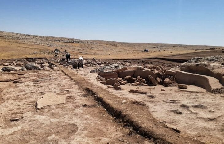
Excavation exposed semi-subterranean rectangular buildings — rooms cut partly down into the ground rather than raised on it. The walls are dry masonry of large limestone boulders, generally around 30 cm and up, stacked without bonding, with mortar used only occasionally.
At the site's heart is a rectangular special building with paired T-shaped pillars — the regional signature, known from Göbekli Tepe, Nevalı Çori, Sefer Tepe and Hamzan Tepe. It was the T-pillars, visible on the surface, that first marked Harbetsuvan out as a Taş Tepeler site.
What has been found
The finds are workaday as much as ceremonial: large numbers of flint and obsidian tools, ground stone, stone vessels, pestles, beads and animal bone. The assemblage shows close parallels with the later levels of Göbekli Tepe.
The sculptural work has been described as sharing characteristics with material from Karahan Tepe and Göbekli Tepe — the same carving tradition, the same interest in the human image, worked at smaller scale.
How old, and how sure
Harbetsuvan is placed in the Early Pre-Pottery Neolithic B, broadly contemporary with Göbekli Tepe's Level II. That dating rests mainly on artefact parallels with Göbekli Tepe rather than on a published series of radiocarbon dates from Harbetsuvan itself.
Anything that gives Harbetsuvan a precise founding date — including claims that it is older than Göbekli Tepe — is running ahead of the published evidence.
What is still unknown
Harbetsuvan has had three excavation seasons and one geophysical campaign, and no full site monograph exists. Its internal chronology is thin, and the function of the excavated building is disputed — a debate we take up on the companion page on why the site matters.
How much was lost to looting before salvage work began may never be recoverable. This is a thinly published site, and its picture will keep moving.
Common questions
Where is Harbetsuvan Tepesi?
In the Tek Tek Mountains, Eyyübiye district, Şanlıurfa province — about 55 km southeast of Şanlıurfa, 7 km from Karahan Tepe and around 35 km from Göbekli Tepe, at roughly 714 m elevation.
What is at Harbetsuvan Tepesi?
A small settlement of semi-subterranean rectangular buildings, including a special building with paired T-shaped pillars, plus flint and obsidian tools, ground stone, vessels, beads and sculptural work sharing traits with Karahan Tepe and Göbekli Tepe.
How old is Harbetsuvan Tepesi?
It is placed in the Early Pre-Pottery Neolithic B, broadly contemporary with Göbekli Tepe's Level II. That rests mainly on artefact parallels, not a published radiocarbon series from the site itself.
How big is Harbetsuvan Tepesi?
Geophysical survey puts it at roughly 5,900 square metres — small by Taş Tepeler standards.
When was Harbetsuvan excavated?
It was published by Bahattin Çelik in 2016, salvage-excavated from 2017 to 2019 after looting pits were found, and has been under renewed Turkish–Japanese excavation since 2022.
Sources & further reading5 references
- Çelik, B. (2016). A small-scale cult centre in Southeast Turkey: Harbetsuvan Tepesi. Documenta Praehistorica 43: 421–428. doi:10.4312/dp.43.21 link
- Uludağ, C. & Çelik, B.. Yeni Bir Çanak Çömleksiz Neolitik Dönem Kazısı: Harbetsuvan Tepesi. Türk Tarih Kurumu (Kazı Sonuçları). Primary report of the 2017 salvage excavation. link
- Archaeological Prospection (2025). The Layout and Size of an Early Pre-Pottery Neolithic B Small Settlement Revealed by Geophysical Prospection at Harbetsuvan Tepesi in Southeastern Anatolia. Archaeological Prospection. doi:10.1002/arp.70037 link
- Shimogama, K. (2024). Harbetsuvan Tepesi (Taş Tepeler project settlement profile). Şanlıurfa Neolithic Research Project – Taş Tepeler. tastepeler.org/en/yerlesmeler/harbetsuvan
- Clare, L. (2020). Göbekli Tepe, Turkey. A brief summary of research at a new World Heritage Site (2015–2019). e-Forschungsberichte des Deutschen Archäologischen Instituts 2020(2): 81–88.
Full bibliography: the Taş Tepeler reference library →