Harbetsuvan · Structure
One excavation area at Harbetsuvan, best understood through the whole-mound picture: a dense village of small rectangular rooms, one of which — in Area D6 — is shown with a sunken floor in the project's own figures.
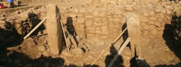
Hasan Gülday, Harbetsuvan Hill, CC BY-SA 4.0, via Wikimedia Commons.
01
02
Area D6 is best read not as a monument but as one part of a small, densely built village. A 2025 geophysical survey of the whole mound, published in Archaeological Prospection, mapped Harbetsuvan as an area of roughly 5,900 m² with deposits about 2.4 m thick, packed with something like fifty small rectangular rooms in the central area — and, tellingly, with no monumental buildings and no large open plazas anywhere on the site. That is the opposite of the pattern at Göbekli Tepe or Karahan Tepe, and it frames every individual room here, including the one in Area D6, as domestic-scale architecture.
03
Within that fabric, the Taş Tepeler project's own figures label a subterranean, pit-floored room in Area D6 — a space set below the surrounding surface rather than built up from it. Beyond that, the honest position is that the detail is not yet public: the full plan, dimensions, entrance, floor treatment, deposits and function of this room have not been published. It is included here as a documented feature of the excavation, not as a fully described building, and should sharpen as the project reports its trenches.
04
Full bibliography: the Taş Tepeler reference library →
Last reviewed 7 October 2026. Something wrong?